


The second of the two RAF bases visited on Wednesday. The day started out really overcast but brightened up nicely into a hot afternoon which made me break out into a sweat a few times. I kept the light jacket on just to give added protection to my arms when walking amongst the thorns and brambles. I first visited the PB located out on the the edge of Blounts Farm just past Fiddlers Brook. As i said the day had opened up to be a really fine day. The farmer was in the field opposite where i parked up and we had a good chat about my intentions before i wandered off into the distance. He's probably used to us nuttersw wandering around now so probably just grinned, shook his head and carried on his days work. Anyhow - less of my spiel and onto the business of documenting a fantastic site......................
The history of the site
Originally used as an Air Landing Ground during WWI.
Three Runways made from Sommerfeld tracking and linked by a concrete perimeter track were added during its later use in WWII.
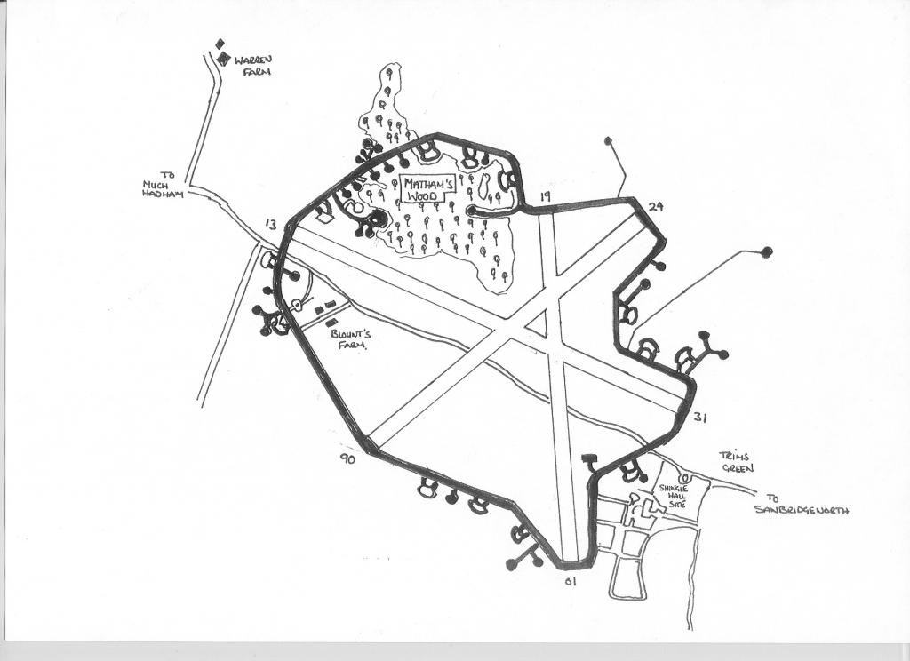
In 1937 an Advanced Landing Ground (ALG) was established to the North of the Much Hadham road near Mathams Wood. This consisted of a 43 acre site and originally named as Mathams Wood ALG. This was on the site of a night landing ground dating from WWI that used land to the west of Shingle Hall. The ALG was under control of North Weald and in use until November 1918 when it reverted to agriculture again. Some peacetime flying by a glider club saw some use of the 31 acre site during the late 1920's through to the middle of the next decade.
In May 1940, the capitulation of France saw many varied squadrons returning home, amongst the Fighter and Light Bomber units were Army Co-operation Squadrons equipped with the high wing Westland Lysander aircraft. These had been used for Artillery spotting and co-ordination, and needed somewhere to go. II(AC) Squadron was one such unit. When the Squadron returned from France in 1940, it landed at Hatfield aerodrome in Hertfordshire, but deHavilland were not happy with the squadrons aircraft parked there, as they thought it would attract enemy aircraft to the valuable aircraft factory on the site. It was decided to take the aircraft to nearby Mathams Wood ALG, not knowing then that this site would would be their home on and off for the next four years.
W/C Geddes the Commanding Officer of the squadron was responsible for making the changes to the airfield that resulted in the eventual size it became. Great Hyde Hall was requisitioned first as the HQ, along with Blounts Farm nearby. Up to late 1940 the Air Ministry still referred the site as Mathams Wood ALG, but W/C Geddes referred to it in a telephone conversation one day to the Air ministry as 'RAF Sawbridgeworth'. The Air Ministry were told that the ALG was being upgraded by local labour to suit the squadrons needs and the name stuck. Later, the squadron traded their Lysanders for the P-40 Curtiss Tomahawk for a while, until being equipped with the new North American P-51 Mustang. Called the Mustang 1 by the RAF.
A "T2" Hanger was erected on the Shingle Hall site, with 16 blister hangers situated around the perimeter track of 40 feet wide. "Blenheim" type aircraft pens, of which the last remaining one appear's in the photo's, were located around the perimeter track.
The flying control tower was situated near Shingle Hall, but was demolished after the war as was the T2 Hangar. Another six dispersed site's were built for accomodation along Parsonage Lane.
The runways were Sommerfeld tracking with a Coir matting underlay on grass, and were arranged as thus; main runway orientated at 130°/310° at 1700 yards in length, secondary runway 060°/240° at 1400 yards in length and the third 010°/190° at a length of 900 yards.
Airfield lighting was provided of the 'Drem' type , normally built in to the edge of the concrete runways and tracks, these were set in concrete blocks off to the sides of the perimeter track and runways instead.
Many varied Squadrons operated out of Sawbridgeworth during it's short wartime life, notably No 2 or II(AC) Squadron operating lysanders,Tomahawk 1's then Mustang 1's were the principal squadron at Sawbridgeworth, This Squadron undertook Ops in support of the Army for photographic, spotting, and Message dropping flights. Other Squadrons at Sawbridgworth were No 63, 168 and 170 Squadrons(Mustang 1's) 4 Squadron (Mustangs), then later in 1944 with Spitfire (PR), 4 Squadron( B flight Mosquito PR16) 80 Squadron (Spitfire 9b) 182 Squadron (Typhoon 1b) 268 Squadron (Tomahawk1/2 Lysander, Spitfire) A detachment to Sawbridgeworth whilst flying Mustang Mk.1 aircraft, commencing June 15, 1942, concluding about August 9, 1942. They were based at Sawbridgeworth whilst flying Mustang Mk.1A aircraft until they moved to Dundonald for Naval Gunnery Direction training and then onto their next major base, Gatwick on April 8, 1942. 126 Squadron (Spitfire 1Xe's). SOE 1419 Flight, later to become 138 (SD) Squadron, with Lysanders moving to Tempsford . This flight also operated Whitley Bombers converted to the role of agent dropping. A Lockheed Hudson aircraft was also allocated to the Squadron, they were known to have used North Weald, Stapleford Abbots in Essex, Stradishall & Newmarket in Suffolk as operating bases.
Special Duties and Special Operation's Executive were involved in the clandestine operations that included dropping or landing trained agents in occupied Europe. Landing a range of aircraft in remote areas, sometimes right under the Germans noses. They also undertook supply drops of arms, ammunition, and explosives, for use by the resistance fighters. One of the most well known airfields for these types of operations was Tempsford in Bedfordshire, and its resident 161(SD) squadron. 138(SD) were also based there. Lysander aircraft from 419,later 1419 flight used Sawbridgeworth for training, in fact the art of short landing by a simple three lamp flarepath, was perfected in the fields around Sawbridgeworth airfield by II(AC) squadrons aircraft. Several 'long range air tests' were undertaken by Geddes and Scotter of II(AC) With Scotter landing at Hornchurch with a blackout curtain rigged inside the rear part of the cockpit, hiding the passenger. This suggests clandestine flights by 'black' Lysanders may well have taken place, and originated at Sawbridgeworth itself. Due to the secretive nature of SOE and it's operations, this has never been, or can be confirmed by documentation.
The airfield defences are still evident, for instance,on the Much Hadham road is a type 24 Pillbox with the remains of the road barrier placed next to it. This point marked the boundary of the airfield. The Much Hadham road that runs through the remains of the airfield, would have been shut at his point during the War. Traffic was probably diverted down and around Allens Green to get around the airfield.
The runways were Sommerfeld tracking on grass. There are references to an Air Ministry experiment using Coir underlay. This was made from coconut husks woven into a matting, and laid across the grass runways. But apparently it was a disaster at Sawbridgeworth due to the high water table. For the matting soaked into the grass and turned into a marsh for several weeks in the winter time. This prohibited the heavier aircraft from using the field, "B" flight of 4 Squadron operating their Mosquito aircraft, were forced to operate their aircraft from Hunsdon for a time.
Driving up to the first PB to come into view. This was located outside the perimeter track which is almost complete. The only section missing is the area of track that would have ran from behind Blounts Farm itself.
PILLBOX (VARIANT): S0013438

The SE embrasure looking out across the approach to the base so protecting the southern approach.


The NW embrasure:

The metal structure described as a possible light tower? The road cutting through the base was closed for the duration of the war and as such would have had a roadblock at this site. The PB makes perfect sense for that purpose but the metal structure is possibly part of the the remnants of the roadblock.


Located just slightly further up the road and located outside the perimeter track. Sited almost equidistant between the extent PB documented above and the destroyed PILLBOX: S0013435. Could this have been an ammunition store. The destroyed / removed PB would have been sat very close to some possible dispersal pens.


Finally parking up i then took that walk across the field along the perimeter track that looked to exist at its original spec. There was evidence of hardcore existing in areas which was made up of cobbles.
The first view in Mathams Wood and to the left and outside of the of perimeter track:

PILLBOX (VARIANT): S0013441
Described as a modified type 22 and only having two three stepped embrasures.


From the inside looking out.


Positioned either side of the PB were two trenches :

The proximity of the support trench.

Concrete sandbags.

And on the other side and facing out of the wooded area:


Support span for a Nissan hut?

Located between S0013441 and S0013440 :


Both Pillbox S0013440 and S0013439 had a series of trenches either side and over the course of the walk i was to find a fair amount of these around.


PILLBOX (VARIANT): S0013440
A type 22 but with the extended embrasures.


PILLBOX (VARIANT): S0013439


Another trench to the right of the PB as you face south towards Blounts Farm across the field.


After crossing over the perimeter track and spotting the high banking.
The first view of the dispersal pen :

The view of the blast wall and entrance to the air raid shelter which adjoined the dispersal pens.


The perimeter track leading off the dispersal pens.
Further down the track are two accessible dispersal pens which are described as originally housing Blenheims.


The view looking out from the dispersal pen onto the perimeter track.


Secondary entrance / exit into the air raid shelter.


The third dispersal pen was covered in a mound of earth and nettles but after getting through the wall of nettles i found this:


Back outside the perimeter, over the fence and past what is described as a spigot mortar housing - another trench. It was by fortune i was having a good nose at this as a car went past me and it was the country neighbourhood watch. Not wishing to be discovered i laid low for a while and then after photographing the trench i stepped through to the other side of the hedgerow. The trench can be located between the Spigot Mortar???? EDOBID: 11946 and PILLBOX (VARIANT): S0013443.


PILLBOX (VARIANT): S0013444
Relatively accessible after crawling under the thickets of thorns. A brief respite was needed for a fag and a drink of coke. Also i knew the car would be back at some point and i wasn't to be proven wrong.


Running low on battery life and determined to photograph the emplacement further up i conserved the battery life on the camera and missed out the PB located between the spigot emplacement and the PB documented above.
SPIGOT MORTAR EMPLACEMENT EDOBID: 11946
I am still not convinced this is a mortar emplacement myself. Possibly and LAA pit but this might be a discussion point.


Squeezing the last juice out of the camera and back to safety over the nasty razor wire.
Sadly i could not document the BATTLE HEADQUARTERS: S0008002 which i so wanted as a prize.
Back another day to finish of this site documentation.
With both RAF based visited i was then allowed to walk back to the car and chance my arm at viewing PILLBOX (VARIANT): S0013434. I fell asleep for around 30 mins knackered after the days walking. The rain was starting to come down in a light drizzle and by attempting to shut the camera off, back on and focus, attempt a few times to take a photo and shut the camera off again i managed to get some shots.
PILLBOX (VARIANT): S0013434


Another lengthy blog but i so hope you all like the content. This site was a real eye opener for me as there was so much to view and discover.
Thanks for being patient and reaching the end.
The history of the site
Originally used as an Air Landing Ground during WWI.
Three Runways made from Sommerfeld tracking and linked by a concrete perimeter track were added during its later use in WWII.
In 1937 an Advanced Landing Ground (ALG) was established to the North of the Much Hadham road near Mathams Wood. This consisted of a 43 acre site and originally named as Mathams Wood ALG. This was on the site of a night landing ground dating from WWI that used land to the west of Shingle Hall. The ALG was under control of North Weald and in use until November 1918 when it reverted to agriculture again. Some peacetime flying by a glider club saw some use of the 31 acre site during the late 1920's through to the middle of the next decade.
In May 1940, the capitulation of France saw many varied squadrons returning home, amongst the Fighter and Light Bomber units were Army Co-operation Squadrons equipped with the high wing Westland Lysander aircraft. These had been used for Artillery spotting and co-ordination, and needed somewhere to go. II(AC) Squadron was one such unit. When the Squadron returned from France in 1940, it landed at Hatfield aerodrome in Hertfordshire, but deHavilland were not happy with the squadrons aircraft parked there, as they thought it would attract enemy aircraft to the valuable aircraft factory on the site. It was decided to take the aircraft to nearby Mathams Wood ALG, not knowing then that this site would would be their home on and off for the next four years.
W/C Geddes the Commanding Officer of the squadron was responsible for making the changes to the airfield that resulted in the eventual size it became. Great Hyde Hall was requisitioned first as the HQ, along with Blounts Farm nearby. Up to late 1940 the Air Ministry still referred the site as Mathams Wood ALG, but W/C Geddes referred to it in a telephone conversation one day to the Air ministry as 'RAF Sawbridgeworth'. The Air Ministry were told that the ALG was being upgraded by local labour to suit the squadrons needs and the name stuck. Later, the squadron traded their Lysanders for the P-40 Curtiss Tomahawk for a while, until being equipped with the new North American P-51 Mustang. Called the Mustang 1 by the RAF.
A "T2" Hanger was erected on the Shingle Hall site, with 16 blister hangers situated around the perimeter track of 40 feet wide. "Blenheim" type aircraft pens, of which the last remaining one appear's in the photo's, were located around the perimeter track.
The flying control tower was situated near Shingle Hall, but was demolished after the war as was the T2 Hangar. Another six dispersed site's were built for accomodation along Parsonage Lane.
The runways were Sommerfeld tracking with a Coir matting underlay on grass, and were arranged as thus; main runway orientated at 130°/310° at 1700 yards in length, secondary runway 060°/240° at 1400 yards in length and the third 010°/190° at a length of 900 yards.
Airfield lighting was provided of the 'Drem' type , normally built in to the edge of the concrete runways and tracks, these were set in concrete blocks off to the sides of the perimeter track and runways instead.
Many varied Squadrons operated out of Sawbridgeworth during it's short wartime life, notably No 2 or II(AC) Squadron operating lysanders,Tomahawk 1's then Mustang 1's were the principal squadron at Sawbridgeworth, This Squadron undertook Ops in support of the Army for photographic, spotting, and Message dropping flights. Other Squadrons at Sawbridgworth were No 63, 168 and 170 Squadrons(Mustang 1's) 4 Squadron (Mustangs), then later in 1944 with Spitfire (PR), 4 Squadron( B flight Mosquito PR16) 80 Squadron (Spitfire 9b) 182 Squadron (Typhoon 1b) 268 Squadron (Tomahawk1/2 Lysander, Spitfire) A detachment to Sawbridgeworth whilst flying Mustang Mk.1 aircraft, commencing June 15, 1942, concluding about August 9, 1942. They were based at Sawbridgeworth whilst flying Mustang Mk.1A aircraft until they moved to Dundonald for Naval Gunnery Direction training and then onto their next major base, Gatwick on April 8, 1942. 126 Squadron (Spitfire 1Xe's). SOE 1419 Flight, later to become 138 (SD) Squadron, with Lysanders moving to Tempsford . This flight also operated Whitley Bombers converted to the role of agent dropping. A Lockheed Hudson aircraft was also allocated to the Squadron, they were known to have used North Weald, Stapleford Abbots in Essex, Stradishall & Newmarket in Suffolk as operating bases.
Special Duties and Special Operation's Executive were involved in the clandestine operations that included dropping or landing trained agents in occupied Europe. Landing a range of aircraft in remote areas, sometimes right under the Germans noses. They also undertook supply drops of arms, ammunition, and explosives, for use by the resistance fighters. One of the most well known airfields for these types of operations was Tempsford in Bedfordshire, and its resident 161(SD) squadron. 138(SD) were also based there. Lysander aircraft from 419,later 1419 flight used Sawbridgeworth for training, in fact the art of short landing by a simple three lamp flarepath, was perfected in the fields around Sawbridgeworth airfield by II(AC) squadrons aircraft. Several 'long range air tests' were undertaken by Geddes and Scotter of II(AC) With Scotter landing at Hornchurch with a blackout curtain rigged inside the rear part of the cockpit, hiding the passenger. This suggests clandestine flights by 'black' Lysanders may well have taken place, and originated at Sawbridgeworth itself. Due to the secretive nature of SOE and it's operations, this has never been, or can be confirmed by documentation.
The airfield defences are still evident, for instance,on the Much Hadham road is a type 24 Pillbox with the remains of the road barrier placed next to it. This point marked the boundary of the airfield. The Much Hadham road that runs through the remains of the airfield, would have been shut at his point during the War. Traffic was probably diverted down and around Allens Green to get around the airfield.
The runways were Sommerfeld tracking on grass. There are references to an Air Ministry experiment using Coir underlay. This was made from coconut husks woven into a matting, and laid across the grass runways. But apparently it was a disaster at Sawbridgeworth due to the high water table. For the matting soaked into the grass and turned into a marsh for several weeks in the winter time. This prohibited the heavier aircraft from using the field, "B" flight of 4 Squadron operating their Mosquito aircraft, were forced to operate their aircraft from Hunsdon for a time.
Driving up to the first PB to come into view. This was located outside the perimeter track which is almost complete. The only section missing is the area of track that would have ran from behind Blounts Farm itself.
PILLBOX (VARIANT): S0013438
The SE embrasure looking out across the approach to the base so protecting the southern approach.
The NW embrasure:
The metal structure described as a possible light tower? The road cutting through the base was closed for the duration of the war and as such would have had a roadblock at this site. The PB makes perfect sense for that purpose but the metal structure is possibly part of the the remnants of the roadblock.
Located just slightly further up the road and located outside the perimeter track. Sited almost equidistant between the extent PB documented above and the destroyed PILLBOX: S0013435. Could this have been an ammunition store. The destroyed / removed PB would have been sat very close to some possible dispersal pens.
Finally parking up i then took that walk across the field along the perimeter track that looked to exist at its original spec. There was evidence of hardcore existing in areas which was made up of cobbles.
The first view in Mathams Wood and to the left and outside of the of perimeter track:
PILLBOX (VARIANT): S0013441
Described as a modified type 22 and only having two three stepped embrasures.
From the inside looking out.
Positioned either side of the PB were two trenches :
The proximity of the support trench.
Concrete sandbags.
And on the other side and facing out of the wooded area:
Support span for a Nissan hut?
Located between S0013441 and S0013440 :
Both Pillbox S0013440 and S0013439 had a series of trenches either side and over the course of the walk i was to find a fair amount of these around.
PILLBOX (VARIANT): S0013440
A type 22 but with the extended embrasures.
PILLBOX (VARIANT): S0013439
Another trench to the right of the PB as you face south towards Blounts Farm across the field.
After crossing over the perimeter track and spotting the high banking.
The first view of the dispersal pen :
The view of the blast wall and entrance to the air raid shelter which adjoined the dispersal pens.
The perimeter track leading off the dispersal pens.
Further down the track are two accessible dispersal pens which are described as originally housing Blenheims.
The view looking out from the dispersal pen onto the perimeter track.
Secondary entrance / exit into the air raid shelter.
The third dispersal pen was covered in a mound of earth and nettles but after getting through the wall of nettles i found this:
Back outside the perimeter, over the fence and past what is described as a spigot mortar housing - another trench. It was by fortune i was having a good nose at this as a car went past me and it was the country neighbourhood watch. Not wishing to be discovered i laid low for a while and then after photographing the trench i stepped through to the other side of the hedgerow. The trench can be located between the Spigot Mortar???? EDOBID: 11946 and PILLBOX (VARIANT): S0013443.
PILLBOX (VARIANT): S0013444
Relatively accessible after crawling under the thickets of thorns. A brief respite was needed for a fag and a drink of coke. Also i knew the car would be back at some point and i wasn't to be proven wrong.
Running low on battery life and determined to photograph the emplacement further up i conserved the battery life on the camera and missed out the PB located between the spigot emplacement and the PB documented above.
SPIGOT MORTAR EMPLACEMENT EDOBID: 11946
I am still not convinced this is a mortar emplacement myself. Possibly and LAA pit but this might be a discussion point.
Squeezing the last juice out of the camera and back to safety over the nasty razor wire.
Sadly i could not document the BATTLE HEADQUARTERS: S0008002 which i so wanted as a prize.
Back another day to finish of this site documentation.
With both RAF based visited i was then allowed to walk back to the car and chance my arm at viewing PILLBOX (VARIANT): S0013434. I fell asleep for around 30 mins knackered after the days walking. The rain was starting to come down in a light drizzle and by attempting to shut the camera off, back on and focus, attempt a few times to take a photo and shut the camera off again i managed to get some shots.
PILLBOX (VARIANT): S0013434
Another lengthy blog but i so hope you all like the content. This site was a real eye opener for me as there was so much to view and discover.
Thanks for being patient and reaching the end.
Last edited:
")

 . Found it a very interesting write up and this got me looking at the photos more. Very nicely done mate