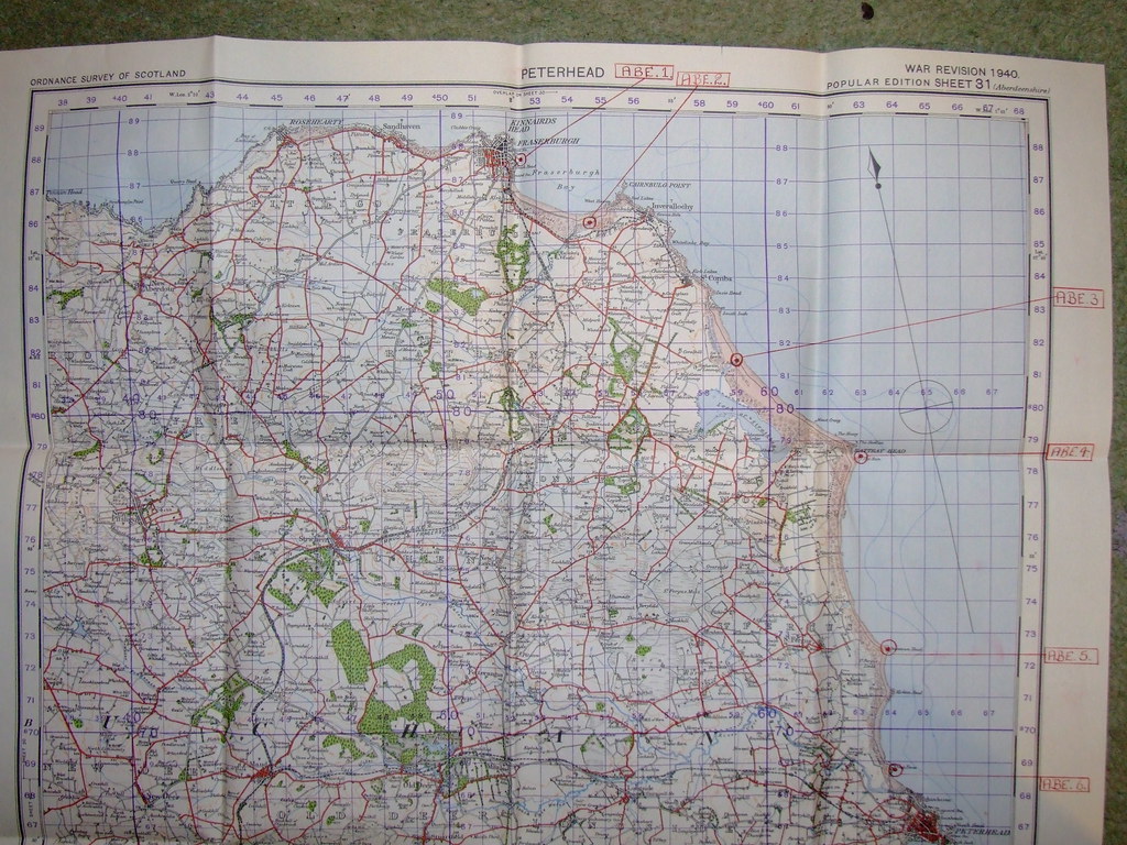
The Historian has hit the nail right on the head. They ARE vulnerable points... they were deemed the most likely points of attempted landing and/or first strike.
ABE.1 is the likely entry point into Fraserburgh and beyond should an attack come in over the sands, or up the road from Inverallochy if landing was successful there. There was another structure, on a circular brick and concrete base, actually in the dunes themselves. Possibly as a watch post? There is evidence of a central iron pivot of some sort, so something was mounted there. Searchlight? I think we've already managed to discount the possibilty of it being a spigot mortar position in an earlier thread.
ABE.2 is at the Water of Philorth, and would have afforded a suitable place to land armour and get it inland as fast as possible with minimal natural obstacles. The inlet was therefore heavily sown with anti tank blocks, and a pillbox stood at the top of the beach to warn of, rather than guard against, a landing at that point. Additionally, the domestic site for RAF Inverallochy is just behind the dunes, and the hill overlooking this spot was chosen as the site for the Battle HQ, rather than locating it closer to the airfield itself.
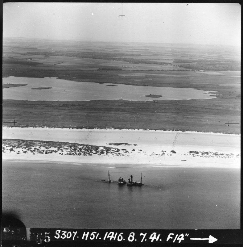
ABE.3 was identified as another point where it was thought likely to be easier to get in and off the beach quickly. As a result, a block ship was sunk at the mouth of the inlet, the beach behind sown liberally with anti tank traps, and the the area to the North of the Loch of Strathbeg being protected by heavily camouflaged pillboxes hidden behind the sand dunes.
ABE.4 is another path through the sand dunes. Marked rather nicely with the very prominent Rattray Head Lighthouse to guide them in, it would have been a simple task to get off the beach, and straight on along to the main road south. Except for the fact that the area was VERY densely populated with the southern elements of the Rattray Stop Line. Including the cleverly disguised pillbox, and barn with loopholes (see thread here... [ame]http://www.derelictplaces.co.uk/main/showthread.php?t=13672[/ame]). Additionally, the coastguard lookout just to the north would have been used to keep an eye out, and had its own pillbox to look after it. This is also considered a very high risk area, due to Rattray/Crimond airfield being located just west of the Loch.
ABE.5 at Kirkton Head was also identified as a possible landing site, but while there is no natural inlet in the area, the dunes do have gaps where it would have been possible to advance quickly inland. It's near here that there is a wooden comms mast still standing, with concrete footings and other eveidence of miltary buildings. Again, anti tank blocks were used extensively, even where the ground is very rocky and apparently unsuitable for landing, as it's probable the granite would have just ripped the bottom out of the landing craft. Obviously, the powers that be were taking no chances.
ABE.6 is a little strange. They have missed off an obvious vulnerable spot between here and ABE.5 on the map, although a pillbox is sited at the entrance to a burn, and the gap stopped up with anti tank blocks. Mind you, getting through the gap would have been easy, but once in, you are in a gully with steep sides, so perhaps it wasn't thought of as being all that particularly vulnerable to armour or other vehicles, since they would have been trapped to a certain extent.
However, here at
ABE.6, there is nowhere to go except take a left on the beach and head for Peterhead over the river Ugie. The area is not only extremely rocky, but the sand dunes are very steep and high. There is a pillbox at this location however, and in the dunes just above it is where I found several spent rounds, and evidence of someone firing inland. The spot is still littered with lead shards. I'm confused, I must admit.
The rest of the map shows similar Vulnerable Points from peterhead southwards. Once you've taken a wander around some of the points annotated, it becomes obvious what was being indicated on the map. Just goes to show the importance of actually getting out there and looking when doing any reasearch. Surfing t'internet is all very well, but it doesn't hold all the answers. Although it is an extremely valuable tool.


")