You are using an out of date browser. It may not display this or other websites correctly.
You should upgrade or use an alternative browser.
You should upgrade or use an alternative browser.
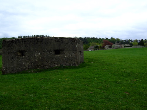
Pillbox near Hornby, Lancashire - May 2010
- Thread starter Seahorse
- Start date


Help Support Derelict Places:
This site may earn a commission from merchant affiliate
links, including eBay, Amazon, and others.
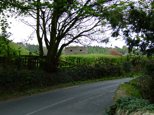
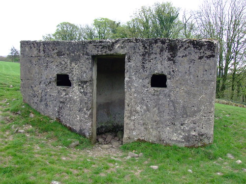

Love that first pic...it looks as if it's peeping over the hedge at you. And in the third pic it looks very happy to have a visitor. 
Yeh, I know I'm odd...I'll get me coat!")
Yeh, I know I'm odd...I'll get me coat!
Is this the one in the grounds of Hornby Castle ?
Phil
Phil
Seahorse
Grumpy auld mod.
Hmm, no it isn't Phil. But you mentioning a castle, made me look closer at the Google Maps link, and I was somewhat intrigued to see that the pillox is set at the edge of a well rounded shape on the ground, that I just took to be a natural hill in the field. How wrong I was.
OK, so a quick Google for info turns up LOADS of info. 2 Derelict Places for the price of 1: a pillbox AND an ancient Motte and Bailey.
Ladies and Gents, may I present Castle Stede.
From this bloke's blog here...
And all down to my sister in law taking me on a sightseeing tour of the area yesterday.
OK, so a quick Google for info turns up LOADS of info. 2 Derelict Places for the price of 1: a pillbox AND an ancient Motte and Bailey.
Ladies and Gents, may I present Castle Stede.
From this bloke's blog here...
Castle Stede
Hornby
Lancashire
One mile North of Hornby, just off the A683, the earthwork remains of Castle Stede guard the crossing of the river Lune. Together with motte and bailey castles to the North in Arkholme, Whittington and Kirkby Lonsdale, to the East in Melling, and to the South in Halton, this is the largest concentration of these earthwork remains to be found outside of Wales. Of these castles, Castle Stede is perhaps the largest, most complex and best preserved example in the area and even possibly in the UK.
The remains are easily accessable from the road to the south of the bailey. You can park on the other side of the bridge, and walk back towards the remains. Entry is through a thin gap in the wall, a short walk up the field, and the entrance to the bailey is marked by a modern stone causeway over the ditches.
The remains are thought to be from the 13th century, and overlay the remains of an iron age hill fort. From this, it's plain to see that the river crossing here was very important from the earliest of times. The motte is approached through the bailey, which is laid out to the left and right as you cross over the causeway. The earthwork ditches and banks are still very much in evidence, providing good defensive barriers against any attack. The oval shaped bailey is around 70 by 60 metres, and is surrounded by a ditch and raised bank reaching an additional height of around 2 metres in places. The North and West sides of the bailey are also protected by the high sided natural embankment, with the North side falling away sharply towards the river, some 40 feet below.
The motte stands at the far Eastern end of the bailey, seperated by a deep ditch, some 3 metres deep. The motte itself stands to a height of around 8 metres, with a fairly flat summit of 15 metres across. The motte is fairly intact, but suffers slightly from rabbits and a few mature trees growing from the sides. The base of the motte has been walled up, probably to prevent any slippage, and this, unsightly as it is, seems to have done the trick. The motte is protected on its West, South and East sides by ditches and emmbankments, still very much in evidence. The North face of the motte decends to the river, again around 40 feet below.
There is documentary evidence to suggest that the castle was in use in 1205, when it was taken from Roger de Montbegon by King John, and returned a mere three months later. There doesn't seem to be any other sites to which this documentary evidence could relate to....Hornby castle some two miles to the East wasn't built until much later.
So important was the crossing here just outside Hornby, that a pill box was constructed during the second world war, no doubt designed to offer protection of the river crossing in the event of a German invasion.
And all down to my sister in law taking me on a sightseeing tour of the area yesterday.
Foxy's right, that's a little cutie and all on it's own. Or is it?
Just had a look on Capn's DOB overlay. This one (S0002945) apparently has a companion (S0015672). Can you confirm whether there was anything else there?
Just had a look on Capn's DOB overlay. This one (S0002945) apparently has a companion (S0015672). Can you confirm whether there was anything else there?
Seahorse
Grumpy auld mod.
Hmmm. Well, there was nothing immediately obvious that I saw when I visited. But that's not to say it wasn't hiding in the trees. Have you got coords? I don't have access to the DB out here just now, and not due home for another couple of weeks.
Hmmm. Well, there was nothing immediately obvious that I saw when I visited. But that's not to say it wasn't hiding in the trees. Have you got coords? I don't have access to the DB out here just now, and not due home for another couple of weeks.
Hope this helps then;

From the DB;
1st Pillbox (probably the one you saw)
Pillbox, scheduled with motte and bailey castle.
(Source: English Heritage schedule )
Type of site PILLBOX
Location Castle Stede motte and bailey castle, Hornby.
Area Hornby with Farleton, Lancashire, England
Grid reference SD 5828 6975
Period WW2
Condition Extant but condition unknown
Materials Reinforced Concrete
Recorder [Unknown] ([Unknown])
Defence grouping Western Command Stop Line No 16 - The stop line runs from Lancaster, via the River Lune to Sedbergh
DOB site reference: S0015672
Associated Identifier Scheduled Monument (ref: 13413)
Event Construction, In the period 1940 1941
2nd Pillbox (the one that ran away and hid when it saw you coming)
Pillbox, no specification.
(Source: Field Visit )
Probable type 24 pillbox standing on terrace to E of river bridge. Concrete faced.
(Source: Field Visit 2001/05/03)
Type 22 pillbox.
(Source: Field Visit )
Type of site PILLBOX (TYPE FW3/22)
Location Loyn Bridge, Hornby Castle, on road to Gressingham E of River Lune.
Area Gressingham, Lancashire, England
Grid reference SD 584 696
Period WW2
Condition Good
Materials Reinforced Concrete
Recorder Sutcliffe, Trevor T.
Defence grouping Western Command Stop Line No 16 - The stop line runs from Lancaster, via the River Lune to Sedbergh
Photographs (1) - exterior view (Roy Bowker).
DOB site reference: S0002945
Original Reference 8321
Event Construction, In the period 1940 1941
Field Visit, On 2001/05/03
Field Visit, By 2001
The overlay symbols (both red) for the two pillboxes are right next to each other. In other words, if it were where the overlay says it is, you'd have tripped over it I'm sure. If that's the Loyn bridge, then the little bugger could, as you say, be hiding in the woods.
The second marker is probably in the wrong location. I expect the Capn' will have the answer.
Congrats on the castle btw. Bet you weren't expecting that!
Last edited:
Seahorse
Grumpy auld mod.
Aye, t'is indeed the Loyn bridge. Pity that's only a 6 figure grid ref. But still, I think I would have spotted it if it was that close. It's a wide open field after all.
I'll no doubt be down that way again some time, so I'll pop along for another wee look when I can. I'm intrigued now.
Actually, thinking about it, this is probably 2 references for the same pillbox. The first says the recorder is unknown, and if the guy who identified the 2nd one had seen 2, he would have recorded both, don't you think? I'm positive that is what happened.
Last edited:
These are almost certainly duplicate entries in the DoB. There are loads of them, the give away is the large difference in the reference number indicating two different recorders made the entries. It is almost impossible to check for duplicates electronically as so much stuff sits very close to each other. Also the chap who did the second entry listed only a pillbox whilst it's quite obviously a T22, therefore proving conclusively that he was an idiot and not to be trusted
whilst it's quite obviously a T22, therefore proving conclusively that he was an idiot and not to be trusted
I find the same thing a lot on the DoB for my local area too, e.g oh its a hexagonish shape its a T22, and il log it without checking that someone with more observational skills and brain power hasnt got it already, hence double co-ordinates 100metres apart.
Nice pics Seahorse thanks mate.
I find the same thing a lot on the DoB for my local area too...
Yup, same here. I don't often bother to look in the DoB because there are several entries for each pillbox down here, and it's a real pain trawling through them all. The co-ords are well out too, plus the description of the area sometimes has one sited on the opposite side of the river to where it actually is...even the village name wrong in one instance!

Unforunately it's true for pretty much everywhere since very few recorders were professionals like our own krela. I suspect for many it was the first time they'd been asked to use a map, hence the rather vague locational details most sites have. Also like any other task that starts out interesting it soon gets boring logging sites and details get skimped on so you can get out of the rain and cold a bit quicker. Still we can't knock what they achieved since we'd all have bog all to do if they hadn't done the hard work for us
krela
Well-known member
My opinion of the DoB DB is very very low. It is a terrible and pointless waste of money mostly based on hearsay and very poor or non existent research skills. I would say at best it's 20% accurate, around this way at least.
I think what's been done with it since (it's been archived and basically left to rot) speaks volumes about how seriously it was taken.
That being said what cptpies is doing is excellent!
I think what's been done with it since (it's been archived and basically left to rot) speaks volumes about how seriously it was taken.
That being said what cptpies is doing is excellent!
I have to agree with that, even round where I live finding the stop line along the Thames the wording existent but condition unknown gave alarm bells, it seemed obvious that no effort was done to check this as the pillboxes were long gone. The database I have on my digital mapping also has a few anomalies. I tend to cross check with Google earth and where I want to go before going out. Saying that the best line so fat has to be the Sulham valley with all the 28 twins.
In my book "Extant Condition Unknown" = "Someone said it might still be there, but I couldn't be arsed to check".
Unfortunately this means I can't move the whole lot of that category into the removed section because a lot of them do still exist but can't be seen on Google Earth.
In my experience the category to mistrust most is "plotted from a German map of defences". I suspect Gefreiter Schultz in OKW Kartographie Abteilung was seeing double after a little too much Schapps at lunch time, every day, for the whole of 1941.
The beauty of this forum is that once the question is posed it's usually very quickly answered.
Thanks for clearing up the mystery one and all.
I'm very keen that this database is correct and will continue to flag up anomalies when I see them.
Thanks for clearing up the mystery one and all.
I'm very keen that this database is correct and will continue to flag up anomalies when I see them.
Seahorse
Grumpy auld mod.
I guess it's easy to knock those that have marked incorrect coords, but once out on the ground it's easy to appreciate how difficult it is in some cases to get even a 6 figure reference correct. Up my way, you stand on a sea of sand dunes, with no distinguishing features to take a bearing from, so it would have been just a best guess based on what you can see.
Mind you, there's absolutely no excuse for not knowing which side of a river you're on, or even getting the village wrong as Foxy has pointed out.
Then along comes GPS and makes experts out of us all, so we can pinpoint things to within a couple of metres. Closer than that recently, in my experience.
Which reminds me... need to get back to Lenabo and map out the airship station before winter turns it into a swamp again.
Similar threads
- Replies
- 7
- Views
- 476